


California Air Basin Map
This page last reviewed March 14 2014
California is divided geographically into air basins for the purpose of managing the air resources of the State on a regional basis. An air basin generally has similar meteorological and geographic conditions throughout. The State is currently divided into 15 air basins. The names of the basins are listed below on the state map or in the Air Basin Directory list. To view the 2012 estimated emissions for an air basin and the counties within the basin, click on the basin map or the basin list.
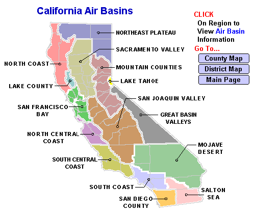
| California Air Basins and Counties (Select Air Basin for Additional Information) | |
| AIR BASINS | COUNTIES |
| Great Basin Valleys | Alpine, Inyo, Mono |
| Lake County | Lake |
| Lake Tahoe | El Dorado, Placer |
| Mojave Desert | Kern, Los Angeles, San Bernardino, Riverside |
| Mountain Counties | Amador, Calaveras, El Dorado, Mariposa, Nevada, Placer, Plumas, Sierra, Tuolumne |
| North Central Coast | Monterey, San Benito, Santa Cruz |
| North Coast | Del Norte, Humboldt, Mendocino, Sonoma, Trinity |
| Northeast Plateau | Lassen, Modoc, Siskiyou |
| Sacramento Valley | Butte, Colusa, Glenn, Placer, Sacramento, Shasta, Solano, Sutter, Tehama, Yolo, Yuba |
| Salton Sea | Imperial, Riverside |
| San Diego | San Diego |
| San Francisco Bay Area | Alameda, Contra Costa, Marin, Napa, San Francisco, San Mateo, Santa Clara, Solano, Sonoma |
| San Joaquin Valley | Fresno, Kern, Kings, Madera, Merced, San Joaquin, Stanislaus, Tulare |
| South Central Coast | San Luis Obispo, Santa Barbara, Ventura |
| South Coast | Los Angeles, Orange, Riverside, San Bernardino |
Please send questions or comments to: eibweb@arb.ca.gov
Local Air District Resource Directory
Other Maps on this Website


